Sp
Menu
English
Arabic
Brazil
French
German
Italian
Russian
Simplified China
Traditional China
Spanish
Turkey
India
Vietnam
Japanese
Korean
sobre la aplicación
Contactos
Sp
English
Arabic
Brazil
French
German
Italian
Russian
Simplified China
Traditional China
Spanish
Turkey
India
Vietnam
Japanese
Korean
This section is not available yet
Inicio
Mapas
Indonesia
Indramayu
Secciones
Mejores lugares
Entretenimiento
Parque
Atracciones turísticas
Mosque
Actividades
Alojamiento
Tiendas
Salud
Hospital
Comida
Educación
Escuela
Transporte
Estación de autobús
Finanzas
Escuela
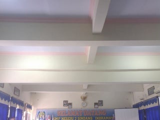
SMP RSBI 2 Sindang
JL Murahnara No 5, Indramayu, Java Occidental, Indonesia, GPS: -6.328312,108.32079
SMPN 2 Sindang, Indramayu
2,5
Estación de autobús
Terminal Dalam Kota
Indonesia, GPS: -6.3358784,108.3343
Hospital
RSUD dan Akademi Keperawatan Pemkab Indramayu
1,5
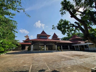
Mosque
Mesjid Agung Indramayu
Jalan S. Parman (Margadadi), Indramayu, Java Occidental, Indonesia, GPS: -6.326752,108.32203
Masjid Agung Indramayu
2,0
Parque
Alun-alun Indramayu
2,9
Jl. R.A Kartini, Indramayu, Java Occidental, Indonesia, GPS: -6.326638,108.3228
Show on map
Show list
MAPS.ME
disponibles
Descarga la aplicación y empieza a ampliar tus horizontes
Abrir la aplicación MAPS.ME
Usar versión web